We are an independent consultancy of urban designers working to create robust and imaginative contributions to the built environment.
We develop responsive masterplans and visions for urban areas with a strong public conscience.
We aim to create distinctive places of exceptional quality through a socially engaged design process.
︎ Home
︎ Recent News
︎ Who We Are
︎ Our Projects
︎ Our Services
♡ Journal
︎ Contact
We are an independent consultancy of urban designers working to create robust and imaginative contributions to the built environment.
We develop responsive masterplans and visions for urban areas with a strong public conscience.
We aim to create distinctive places of exceptional quality through a socially engaged design process.
︎ Home
︎ Recent News
︎ Who We Are
︎ Our Projects
︎ Contact
Shrub Hill Spatial Blueprint, Plot Atlas and SPD
Client: Worcester City Council
Partners: Worcestershire County Council, Worcestershire LEP
Status: Ongoing

Context
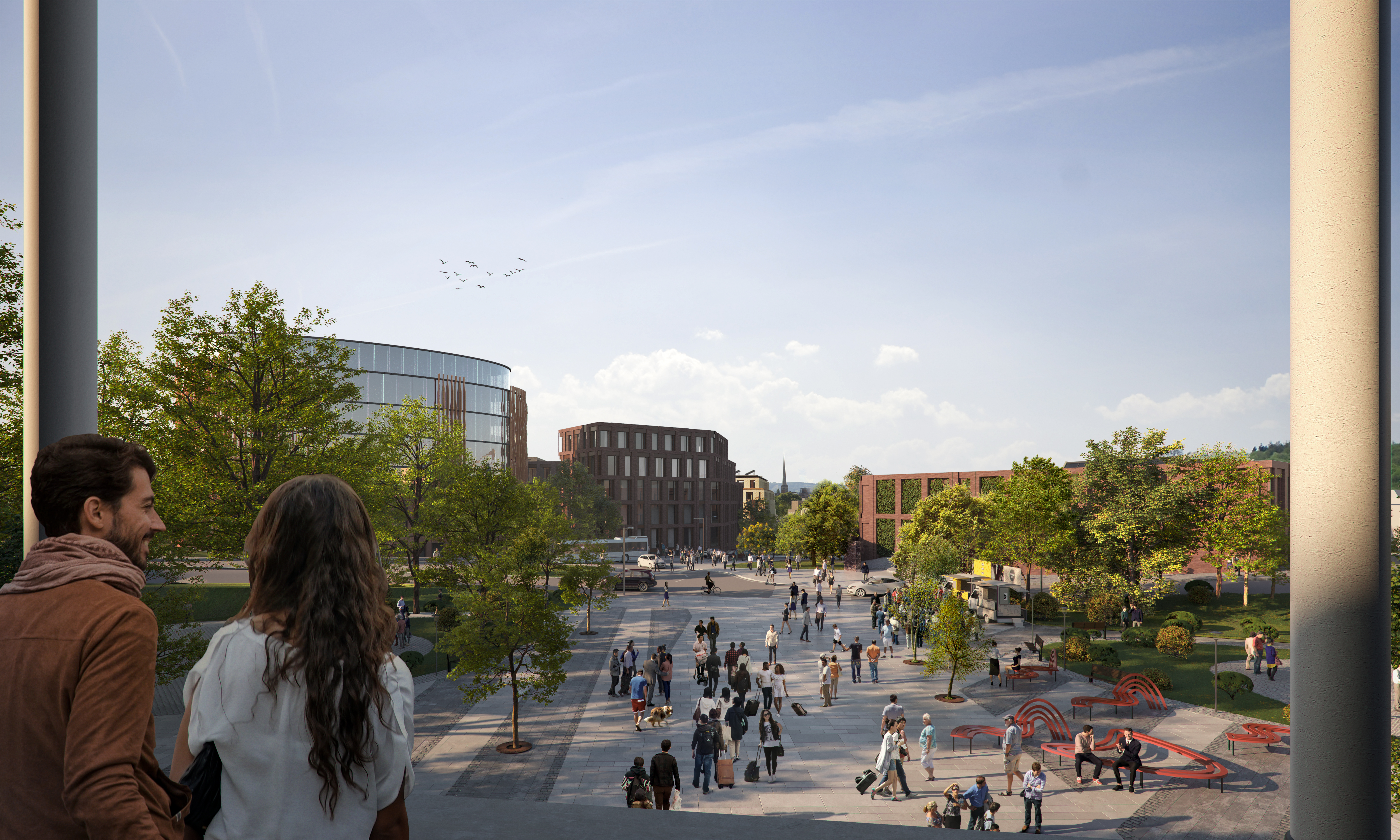
Located in the heart of Worcester City Centre and covering an area of c.14 hectares, the Shrub Hill Quarter is a long-undervalued area with significant untapped potential. Due to its size, location, and strategic connectivity it is a regionally significant regeneration opportunity which has the potential to underpin the long-term vitality, growth, and identity of Worcester as a place to live and work.
The study area is home to several significant heritage assets including Shrub Hill Station and vestiges of the area’s industrial history. Proposed investment in rail infrastructure over the next decade has the potential to transform the quality of regional and national connectivity for Worcester, enhancing the speed and frequency of services from Shrub Hill to cities like Birmingham, Bristol, and London.
Over the years Worcestershire County Council, Worcester City Council, and the Worcestershire LEP have worked together to explore and start to unlock this long-term opportunity. Activities have included the acquisition of sites and joint submission of funding bids to government in 2020 and 2021 to enable initial investment into Shrub Hill, including a successful Towns Fund submission, ongoing submissions to the Brownfield Land Release Fund (to support initial development phases (outcome of bid pending), and to the Levelling Up Fund (to support upgrades to Shrub Hill Station).

Objectives and Key Activities
Ambition 1: Place-making — To create a high quality and distinctive neighbourhood with new residents, new green spaces, new employment and new leisure activities;
Ambition 2: Prosperity — To establish a diverse and productive economy, catalysing the economic growth of the city of Worcester;
Ambition 3: Connectivity — To transform connections from the development area to wider Worcester and beyond, establishing the new neighbourhood’s ‘gateway’ character.
Our team was tasked with the production of a comprehensive, visually appealing, and practical document that fully demonstrates the opportunities and constraints of the study area and explains the design rationale behind the development framework, alongside supporting phasing and delivery strategies.
The Spatial Blueprint had to cover the following:
- Preparing an evidence base including review of policy and market studies to understand appropriate development response
- Technical desktop and site analysis to understand physical opportunities and constraints
- Development of area-wide masterplan design options, rationale, and key design moves
- Testing minimum and maximum parameters for site capacity, scale and massing with regard to deliverability
- Developing supporting strategies in terms of movement and public realm, land use distribution, sustainability, and phasing
- Preparing illustrative materials including high quality plans and visualisations
- A Prospectus, that is a short and non-technical summary version of the report to provide a compelling ‘elevator pitch’ to introduce and communicate the opportunity and aspiration to partners.

Design Response
The Spatial Blueprint fused all the aspects of the historic, current, and future Shrub Hill ‘place’ together into a coherent long-term strategic and spatial vision that can be mobilised immediately. It considers the type of place that Shrub Hill will be and the types of interventions and direct actions that will support this.
Shrub Hill will be Worcester’s exemplary mixed-use urban Quarter and an extension of the City Centre. It will celebrate the City’s great industrial and entrepreneurial spirit and be home to an exciting ecology of makers, professionals, and creative industries. Employment and leisure uses will complement new homes, all set around a re-energized canal. To achieve this objective we added a deliverable to the project by developing a Plot Atlas — a site-based design code that recognises the various qualities of character areas over the site.
Through the Plot Atlas we demonstrated the application of the Shrub Hill Blueprint design principles to the scale of the individual plots on site. This provides a flexible, adaptive design strategy, that ensures integrated and coherent development. It is also a practical, dynamic resource and a valuable reference tool that will help shape, guide, and coordinate future decisions, investments, and activities in the area. The work looked at creating key connections and identifying synergies between Shrub Hill and Worcester City Centre.
Finally, we developed an activation strategy covering public realm, movement, and meanwhile uses and opportunities. The design process explored the physical site issues and constraints (topography, heritage built form, canal and road barriers) and designed positive responses to these, including new and repaired canal bridges, retrofit approaches to heritage buildings and green pedestrian links throughout the site. Stakeholder engagement resolved some land-ownership challenges while others required awaiting lease expiries. These complexities are reflected in the final phasing approach which takes into account varying timelines for aspects of development for the different sites and character areas.
Shrub Hill Quarter Supplementary Planning Document (SPD)
After the development of the Blueprint and Plot Atlas, the Council commissioned ARU to produce an SPD for the site. Preparation of the SPD is now nearly complete and expected to be adopted in Autumn 2024.
The SPD combines the design principles set out by the Spatial Blueprint and Plot Atlas and embeds flexible and adaptable development principles, complemented by relevant and specific character area coding. The illustrative Spatial Blueprint masterplan is also included to demonstrate an acceptable application of the guidance set out by the SPD.
The development of the SPD was underpinned by two rounds of engagement. The first round of engagement on the Spatial Blueprint and Plot Atlas principles took place in August 2023, followed by the second round comprising a 6-week statutory consultation in March 2024. We worked in close collaboration with development managers and planning officers of Worcester City Council, as well as with the Worcestershire County Council, in its role as the Highways Authority for the area. A soft market testing exercise was separately undertaken by Worcestershire County Council, which has provided valuable insight through engagement with potential developers.
Adoption of the SPD is expected before the end of 2024. Once adopted, the Shrub Hill Quarter SPD will be a material consideration when determining any planning applications within the designated Shrub Hill site boundary. This document builds upon and provides more detailed guidance on policies adopted in the Local Plan, such as the site allocation. Its primary role is to guide the physical aspects of developing the Shrub Hill Quarter area, and to help bring about a high-quality development that will contribute to the wider vision for Worcester and Worcestershire areas.
At the time of writing, a planning application for removing the bus wash currently blocking the connection along Cromwell Link, the main active travel route through the site, has been approved. The delivery of the link is expected in 2026.
Public links
https://www.worcestershire.gov.uk/sites/default/files/2023-06/Shrub%20Hill.pdf
https://www.worcester.gov.uk/news/next-steps-in-ambitious-plan-for-worcester-s-shrub-hill-quarter
https://worcesterobserver.co.uk/news/worcester-news-have-your-say-on-worcester-shrub-hill-plans/
https://www.worcester.gov.uk/news/plans-for-future-of-worcester-s-shrub-hill-quarter-to-go-on-display
https://www.bbc.co.uk/news/uk-england-hereford-worcester-67232733